Drombeg Stone Circle: Stones, Excavations and a Mindful Visit
Drombeg Stone Circle is an unguided National Monument near Glandore, County Cork. See what its stones, solstice alignment and excavation finds reveal.
On this page
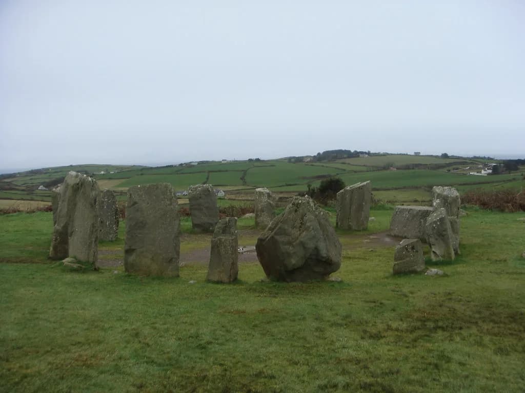
Drombeg Stone Circle is an unguided National Monument in state guardianship, set under three kilometres east of Glandore in County Cork. That official status matters for planning: there is no staffed reception, tour or interpretive building described, so what you meet is the monument in its landscape, read on your own terms.
Approaching it as a single ring of stones undersells the place. The surviving circle, the axial stone with its carved detail, the excavated burial deposit, the hut foundations and the fulacht fiadh cooking place are distinct strands of evidence, and each answers a different question about how the site was made and used.
Where Drombeg Sits and What Survives
Drombeg stands on the edge of a rocky terrace overlooking the sea, about a kilometre away, according to Discover Ireland. Locally it also carries the nickname the Druid's Altar, a folk label attached to the site and recorded by both Discover Ireland and Ireland.com.
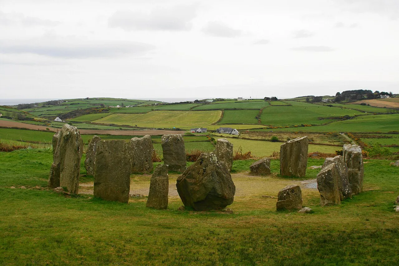
Seventeen upright stones made up the original ring, and the layout is anchored by an axial stone rather than evenly balanced all the way round. Visitors should look for that difference in stone size and position early, because it frames everything else in the design.
The setting rewards a slow circuit rather than a quick photograph. Walk the outside of the ring first to grasp the full outline, then step back to see how the stones sit against the terrain and the horizon.
The Stones, the Entrance and the Axial Stone
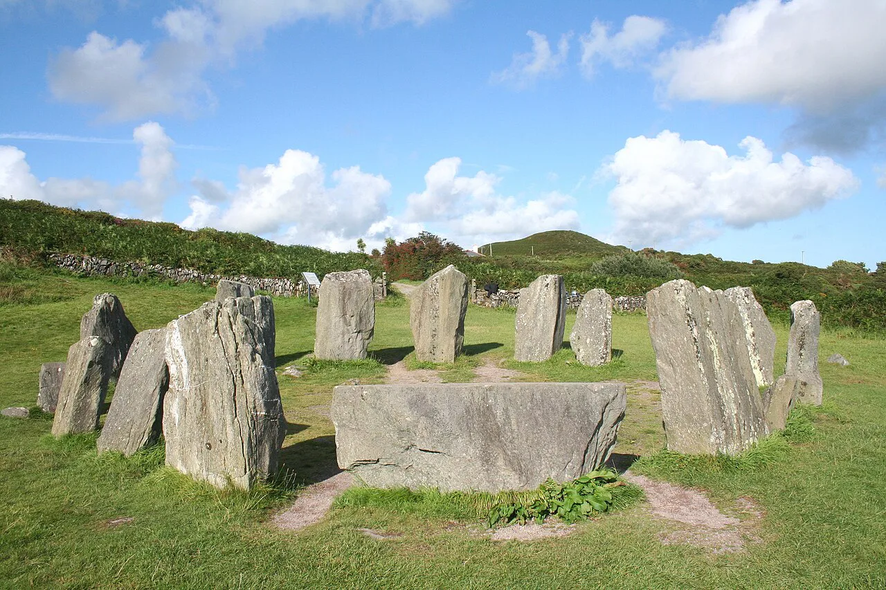
Ireland.com's feature describes two large portal stones, each about two metres tall, marking the entrance to the circle. Look from the entrance toward the axial stone to compare the stones' sizes and positions.
The axial stone is the largest in the ring and carries two shallow cup-marks, one of them with a carved oval motif. These are subtle surface details, easily missed in flat light, so take time at that stone and look closely rather than scanning the ring as a whole.
On a monument with no described visitor centre or guide, the stones themselves are the text. Reading the ring from the axial stone around the full circuit turns a scatter of boulders into a legible composition, and it is the simplest interpretive tool a visitor has.
Sky and Landscape: The Solstice Alignment
The setting sun at the winter solstice lines up with a conspicuous notch in the distant hills, and Discover Ireland describes this alignment as good but not perfectly precise. Heritage Ireland adds that the site's north-east to south-west alignment marks the winter and summer solstices, while Ireland.com describes the winter-solstice sun aligning with the entrance and axial stones. Read the stones against the horizon rather than the ring alone.
Discover Ireland qualifies the alignment as good but not perfectly precise. That description is a reason to compare the stone and the distant notch carefully, without expecting an exact sightline.
If you want to see the effect, look toward the notch in the distant hills in daylight first, then return with the sunset. Whether you can be there at the solstice itself depends on the date and the weather, which no source can promise.
What the Excavations Found
Excavation in the late 1950s opened five pits within the circle, and cremated human remains were found among fragments of shale and shreds of a fabric-wrapped pot. The pot had been deliberately broken, and smashed sherds and sweepings from a pyre were also recovered near the centre.
That record is the reason the interior deserves as much attention as the standing stones. The deposits are gone from view, but knowing they lay beneath the floor changes what the open centre means: it is an excavated space, not an empty one.
Keep the finds in proportion. They tell us about burial and deposition at the monument, but they do not by themselves explain every phase of use or settle questions about the beliefs behind the rites.
Beyond the Circle: Huts and the Fulacht Fiadh
South-east of the circle is a hut site rebuilt more than once. The sequence ran from a C-shaped shelter to a stone hut and then a figure-of-eight stone hut that reused the earlier doorway, with a causeway later added toward the cooking place.
The fulacht fiadh is a horseshoe-shaped cooking place with a U-shaped hearth and a flagged trough. The method was simple and effective: water in the trough was brought to the boil by dropping in heated stones.
Discover Ireland reports that trials of the heated-stone method brought seventy or more gallons of water to the boil and kept it hot for nearly three hours. That is a modern experiment illustrating the technique, not a measurement recorded by the prehistoric users.
Reading the Radiocarbon Ranges
The dates reported for the site and its features come as ranges, not single years. Activity associated with the monument has been placed in the range of 1124 to 794 BC, while remnants from the fulacht fiadh fall much later, at 109 to 349 AD and again at 368 to 608 AD.
Those figures point to intermittent use over a long period rather than one tidy episode of building. The specialists cited by the state guardian suggest the site was used on and off, which fits the multi-period hut sequence and the later cooking activity.
What the ranges cannot do is fix a single construction moment or give a neat biography of the ring. Treat any claim of a precise founding year with caution, and read the dates as brackets around phases of activity.
The Folk Name and the Wider Prehistoric Landscape
The nickname Druid's Altar is a local tradition, and it should be enjoyed as such. Nothing in the excavation record establishes druidic ritual at the circle, so the name is a piece of folklore attaching to the stones; Discover Ireland and Ireland.com both record it as a local name rather than an archaeological finding.
Drombeg belongs to a wider family of prehistoric monuments across the island. For comparison rather than itinerary-building, an Ireland.com feature on ancient standing stones also names Ballynoe in County Down, Beltany in Donegal, Kenmare in Kerry, Drumskinny in Fermanagh and Beaghmore in Tyrone, each with its own character and setting. If you are weighing up which county collections to pair with a monument visit, our Cork heritage guide covers museums and sites in the same region.
Placing Drombeg among these sites helps explain what is ordinary and what is distinctive about it. The ring, the alignment and the excavated deposits together make it a compact introduction to Ireland's ancient sites, a useful frame if you plan to see more of them.
Visiting an Unguided, Protected Monument
Heritage Ireland lists Drombeg as an unguided site and asks visitors to take care and caution while there. Plan on open ground and your own judgment rather than staff, amenities or a visitor centre, and check the official page before travelling for any current notices.
The monument is protected under the National Monuments Acts, so the stones, carvings and earthworks are not to be climbed, moved or marked. Stay on established ground where it exists, keep group noise low, and leave the cup-marks and carved motif exactly as you found them.
Because the site is exposed and unstaffed, weather and footing deserve real attention, and a wet day changes the experience of the open ground. Bring appropriate footwear and treat the visit as a short archaeological walk rather than a stop with amenities.
How Drombeg Compares With Other Sites
For more monuments like this one, read our guide to stone circles in Ireland.
At Drombeg, the ring, huts and cooking place give you several features to examine in one visit. Finish with the hut foundations rather than ending your visit at the standing stones.
Our separate Hill of Tara guide offers another starting point for planning heritage visits.
Plan Your Visit
Approach Drombeg as an hour or so of slow looking. Start with the full ring from outside, find the entrance stones and the axial stone, then check the cup-marks and, at the right season, watch the setting winter sun line up with the notch in the distant hills. For another heritage guide, read about Dun Aonghasa.
Finish at the hut foundations and the fulacht fiadh so the circle reads as one part of a worked landscape. Confirm current access and any notices on the official pages before you set out, since the site is unguided and conditions can change. For further reading, see Bronze Age Ireland, Creevykeel Court Tomb and Ogham Stones Ireland.
Explore more Ireland guides
Frequently Asked Questions
Is Drombeg Stone Circle a guided or staffed site?
No. Heritage Ireland lists it as an unguided site and asks visitors to maintain care and caution. Expect open ground and no described reception, tour or interpretive building, and check the official page before travelling for any current notices.
What do the stones at Drombeg actually show?
The ring originally had seventeen upright stones, with a large axial stone at the back carrying two shallow cup-marks, one with a carved oval motif. Examine that stone closely rather than only scanning the circle, and note the ring's north-east to south-west alignment. Ireland.com's feature also describes two large portal stones marking the entrance.
Does the winter solstice sunset align exactly at Drombeg?
Not with mathematical precision. Discover Ireland describes the setting winter sun lining up with a notch in the distant hills and calls the alignment good but not perfectly precise, and Ireland.com describes the winter-solstice sun aligning with the entrance and axial stones. Heritage Ireland adds that the north-east to south-west axis marks both winter and summer solstices, so the design indicates attention to the turning year without making the circle a precision instrument.
What was found during the Drombeg excavations?
Excavation in the late 1950s found cremated human remains among shale fragments and shreds of a fabric-wrapped pot that had been deliberately broken, along with smashed sherds and sweepings from a pyre near the centre. The deposits are no longer visible, but they explain why the interior matters.
What is a fulacht fiadh and how does the one at Drombeg work?
It is a cooking place, and the example at Drombeg is horseshoe-shaped with a U-shaped hearth and a flagged trough. Water was boiled by dropping in heated stones; Discover Ireland reports that trials of the method boiled seventy or more gallons and kept the water hot for nearly three hours.
How old is Drombeg Stone Circle?
The dates come as ranges. Activity associated with the monument has been placed around 1124 to 794 BC, while fulacht fiadh remnants date later, around 109 to 349 AD and 368 to 608 AD. Together they indicate intermittent use rather than a single construction moment.
Why is Drombeg called the Druid's Altar?
It is a local nickname, not an archaeological finding. Discover Ireland records the folk name, and nothing in the excavation record establishes druidic ritual there, so treat the name as folklore attached to the stones rather than evidence of who used the site.
What should I look at beyond the stone circle itself?
Look for the hut foundations south-east of the ring, where a C-shaped shelter was replaced by stone huts, and for the fulacht fiadh with its trough and hearth. A causeway links these elements, so the visit becomes a short walk through a prehistoric working landscape.
Sources
You might also like
Continue reading
More guides you'll find useful